Next major storm on Monday, deepest snow east of the divide
by Meteorologist Joel Gratz
Summary
We’ll see a few snow showers on Friday afternoon which might drop a dusting to an inch or two on the northern mountains. Then Saturday and Sunday will be dry, with a cold front and snow arriving Sunday late in the evening and continuing through Monday. East of the divide, we could see 6-12 inches in the foothills and snow could accumulate down to the Denver metro area. For the rest of the mountains, we’ll see about 2-4 inches on Sunday night and Monday, with higher amounts possible for areas favored by winds blowing from the east, like perhaps Monarch. Then for the rest of next week, expect drier and warmer weather with the next storm possible around October 16th.
Short Term Forecast
I wrote a few words about cloud seeding and about upcoming talks in the Announcements section below, so scroll all the way, please:-)
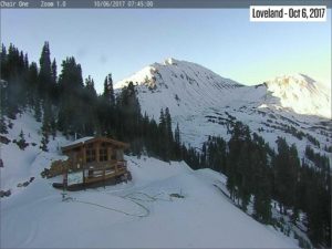
Right now on Friday, October 6th, the north-facing aspects of Loveland are still covered in snow.
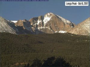
The north and east-facing aspects of Longs Peak are also holding snow.
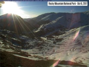
And the Alpine Visitors Center at Rocky Mountain National Park is showing a wintry scene.
With the sun angle getting lower, I think that snow will stick around on many north-facing aspects, even though we will see warmer temperatures next week.
Storm #7 on Friday
We will see a fast-moving and moisture-starved storm today, Friday, October 6th. The northern and central mountains will see a few snow showers, mostly between about 1 pm and 5 pm. Snow accumulations should be light, just a dusting to maybe an inch or two.
This weekend
Saturday and Sunday will be dry and warmer. The eastern peaks will see higher wind speeds on Saturday, and lighter winds on Sunday. If you’re hiking into the higher terrain of the eastern mountains, maybe avoid Saturday – it will be very windy (gusts 40-70mph).
Storm #8 on Sunday night into Monday
On Sunday evening, snow will begin over the northern and eastern mountains, and the snow will hit the central and southern mountains by Monday.
Two points about this storm.
First, it will be cold, with the coldest air east of the divide. We should see snow down to 5,000 feet (effectively all of the Denver metro area) on Monday. Roads might be a bit slick on Monday morning in Denver metro, but the high sun angle of October should allow roads to stay wet through most of the day on Monday. The foothills west of Denver will likely see a better chance for snow-covered roads through the day, though the high sun angle could make things wet here as well.
Second, the track of the storm will bring winds from the east for most of the event, and this will bring the heaviest snow to the foothills east of the divide. A wind direction from the east only favors the foothills east of the divide, and sometimes Monarch and Wolf Creek.
In the foothills east of the divide, we could see 6-12 inches. For areas near and west of the divide, I think 2-4 inches is a better bet due to the unfavorable wind direction, though we could sneak out a bit more if we’re lucky and see stronger, narrow bands of snow.
Reading the models
When I make a forecast, I don’t just look at the model’s snow forecast. I also look at other variables, like wind direction and temperature, so that I can double check the models. If the wind direction isn’t favorable, but the model forecasts a lot of snow, that throws up a red flag.
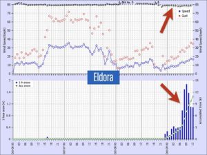
For example, here is the forecast from the CAIC WRF 3km model for Eldora. The red arrows show a wind from the east with 9+ inches of snow on Sunday night. A wind from the east is favorable for Eldora, so the heavy snow makes sense.
However, at Steamboat, a wind from the east is not favorable for snow. Instead, it generally brings a bit of snow, and then the east wind creates very gusty conditions. In this case, the model shows 9+ inches of snow at Steamboat with a strong east wind. This high amount of snow does NOT make sense to me because a wind from the east is not favorable for Steamboat.
It’s important, when forecasting, to look at the whole story and not just focus on the model’s forecast for snow.
Extended Forecast
After Monday’s snow, we should see dry weather for most of next week. The next storm should arrive on or about Monday, October 16th.
Posted from OpenSnow

